
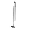
USGS Top Setting Wading Rods
The USGS top setting wading rods are used with instruments that measure water flow rates and discharge in shallow rivers and streams for easy data collection.
Features
- Available in imperial & metric units
- Handle is constructed of anodized aluminum
- Works with many popular flow meters
- Free ground shipping
- Expedited repair and warranty service
- Lifetime technical support
- More
Overview
Wading rods are used with instruments that measure water flow rates and discharge in shallow rivers and streams. In fact, many popular flow meters require a wading rod to operate properly. Some of these include the SonTek FlowTracker, Marsh McBirney Flo-Mate, OTT MF pro, Type AA, and pygmy current meters.
Multiple Styles Available
Two versions of the wading rod are available - one with imperial units for measuring depth and another with metric units. The imperial rod is marked in feet and tenths of feet. It may be ordered in 4' or 6' long models. The metric rod is marked in centimeters and has a length of 1.2m or 1.5m.
Depth Indicators
Water depth can be determined simply by looking at the graduated markings on the wading rod. The anodized aluminum handle incorporates a scale to indicate the correct position of the flow meter at the 0.2, 0.6, and 0.8 depth settings. Probe depth can be adjusted using implemented controls.
- (1) Top setting wading rod
- (1) Threaded base plate with lock washer
Select Options


In The News

Measuring Rising Floodwaters with the USGS
All year long the US Geological Survey (USGS) in North Dakota and South Dakota monitors water levels, but during times of flooding, all eyes are on the team. EM spoke to USGS data chief Chris Laveau about the monitoring efforts. “The US Geological Survey in North Dakota and South Dakota is one entity, so we monitor the flooding in both states,” explains Mr. Laveau. “The role is to provide continuous information on water level, we call that gauge height or stage, and we also provide continuous information at a lot of locations on stream flow, typically called discharge. We do that year round but, obviously, during a flood event it garners more attention.
Read More
Citizen Scientists Tracking Intermittent Rivers
Most of the time when we think of monitoring streams and rivers, we think of water, and for a good reason. However, in some parts of the country, many rivers are intermittent—dry at some point in space or time—and therefore have not had equal amounts of attention from ecologists and hydrologists. A project led by a University of Oklahoma (OU) team is working to change that with the help of citizen scientists. OU assistant professor of biology Daniel Allen spoke to EM about the project and why it's so important to track intermittent rivers. “ The Nature Conservancy (TNC) started the Citizen Science program in Arizona's San Pedro River and the nearby Cienega Creek in, I think, 2001,” details Dr. Allen.
Read More
Supplying Seattle’s Drinking Water: Using Data Buoys to Monitor the Cedar River Municipal Watershed
Providing clean, safe, and reliable drinking water for the 1.6 million people in the greater Seattle area is a top priority for Seattle Public Utilities (SPU). With limited water supplies, SPU dedicates considerable resources to maintain its watersheds and mountain reservoirs. About 70 percent of Seattle Water comes from the Cedar River Municipal Watershed , and the other 30 percent comes from the South Fork Tolt River Watershed . [caption id="attachment_39574" align="alignnone" width="940"] Data buoy in Chester Morse Lake . (Credit: Kevin Johnson / Seattle Public Utilities) [/caption] Jamie Thompson, a fisheries biologist at SPU, monitors aquatic ecosystems centered on fish listed under the U.S. Endangered Species Act (ESA).
Read More