
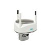
Vaisala WXT531 Rainfall Sensor
Features
- Low power consumption is ideal for battery powered systems
- No moving parts for durability and long maintenance intervals
- Easy integration with 3rd party data collection platforms
- Free ground shipping
- Expedited repair and warranty service
- Lifetime technical support
- More

Flexibility
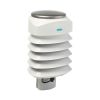
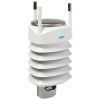
The WXT530 is a series of weather instruments that provides six of the most important weather parameters, which are air pressure, temperature, humidity, rainfall, wind speed and direction through various combinations. Select the transmitter with the needed parameter(s) for specific weather applications, with a large variety of digital communication modes and a wide range of voltages. There is a heated option available. Low power consumption enables solar panel applications. The Vaisala WXT530 Series focuses on maintenance-free operations in a cost-effective manner.
Integration
The series offers analog input options for additional third-party analog sensors. With the help of the built-in analog to digital converters, the Weather Transmitter WXT530 turns into a small, cost-effective weather parameter hub. Additional parameters include the solar radiation and external temperature sensor. Further, the analog mA output option for wind speed and direction enables a wide variety of industrial applications. The WXT530 exceeds IEC60945 maritime standard.
Solid Performance
The WXT530 Series has a unique Vaisala solid-state sensor technology. To measure wind, the ultrasonic Vaisala WINDCAP Sensors are applied to determine horizontal wind speed and direction. Barometric pressure, temperature, and humidity measurements are combined in the PTU module using capacitive measurement for each parameter. This module is easy to change without any contact with the sensors. The precipitation measurement is based on the unique acoustic Vaisala RAINCAP Sensor without flooding, clogging, wetting, and evaporation losses.
Select Options


In The News

Monitoring Mariculture in the Gulf of Alaska
The mariculture industry in the Gulf of Alaska has been steadily growing in recent years, guided by ongoing research to help refine farm location and cultivation practices. A subset of aquaculture, mariculture focuses on rearing organisms in the open ocean. In Alaska, finfish farming is illegal, so most farms cultivate kelp, oysters, or a combination of the two. These small, locally operated farms started popping up in the Gulf of Alaska in the early 1990s, when shellfish farming first became legal. Kelp farming did not begin to catch on in the state until 2016. Many of the coastal areas that have grown interested in mariculture are historically commercial fishing communities.
Read More
Supplying Seattle’s Drinking Water: Using Data Buoys to Monitor the Cedar River Municipal Watershed
Providing clean, safe, and reliable drinking water for the 1.6 million people in the greater Seattle area is a top priority for Seattle Public Utilities (SPU). With limited water supplies, SPU dedicates considerable resources to maintain its watersheds and mountain reservoirs. About 70 percent of Seattle Water comes from the Cedar River Municipal Watershed , and the other 30 percent comes from the South Fork Tolt River Watershed . [caption id="attachment_39574" align="alignnone" width="940"] Data buoy in Chester Morse Lake . (Credit: Kevin Johnson / Seattle Public Utilities) [/caption] Jamie Thompson, a fisheries biologist at SPU, monitors aquatic ecosystems centered on fish listed under the U.S. Endangered Species Act (ESA).
Read More
Data-Driven Advocacy on the Lower Deschutes River
Like many freshwater environments, the Deschutes River in Oregon is under pressure from development, pollution, and climate change. Many rivers, streams and lakes in the Deschutes Basin do not meet Oregon water quality standards –where state water quality monitoring assesses levels of bacteria, pH, dissolved oxygen, temperature, and fine sediment. Hannah Camel is the Water Quality Coordinator for the Deschutes River Alliance (DRA), a non-profit organization that focuses on the health of the lower 100 miles of the Deschutes River–the area most affected by human intervention. As a data-driven organization, the DRA has benefited from the installation of two NexSens X2 data loggers.
Read More