
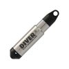
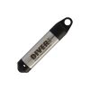
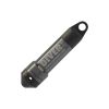
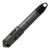
Van Essen Diver-Link Cellular Telemetry System
The Van Essen Diver-Link cellular telemetry system is durable and easy to install with AT&T/T-Mobile networks that can be used in a variety of borehole locations such as flush mount and stick-up wells.
Features
- Automatic barometric compensation: no post processing of data
- 5+ years of battery life
- Compatible with all Diver data loggers and cables
- Free ground shipping
- Expedited repair and warranty service
- Lifetime technical support
- More
Overview
The Van Essen Diver-Link is a telemetry unit that is part of Diver-NETZ, a complete remote monitoring system that integrates field instrumentation with wireless communication and data management to effectively manage (ground)water resources. The Van Essen Diver-Link is suitable for continuous long- and short-term monitoring projects.
Durable
The Van Essen Diver-Link is a durable and easy to install telemetry unit that can be used in a variety of borehole locations such as flush mount and stick-up wells. The Diver-Link transmits data from a Diver data logger over a cellular network. Easily integrate the Diver-Link into the Diver-HUB web portal for real-time management of site data, monitoring equipment and water levels.
Compact Design
The Diver-Link combines a compact design with the latest 4G/LTE wireless technology. Configuration and management of the unit is easily done through the Diver-HUB web portal. Deployment of the Diver-Link simply consists of inserting the battery and connecting the unit to a Diver. In the field, the Diver-Link can be operated through Bluetooth Smart or using the magnetic function keys to activate the unit. Future firmware updates are automatically executed ‘over-the-air’, so there is no need for additional site visits.
Select Options


In The News

Save our Bogs! Culture, Conservation and Climate Action in Ireland’s Peatlands
Characterized by long-term accumulation under waterlogged conditions, peatlands exist on every continent and account for 3-4% of the global land surface . Small but mighty, these often overlooked wetland environments are estimated to hold as much as one-third of the world's organic carbon in their soil—twice the amount found in the entirety of the Earth's forest biomass. While healthy peatlands can trap and store carbon, regulate water, and provide important habitats for rare species, human alteration has disturbed peatland carbon and nitrogen cycles on a global scale. Approximately 12% of the world’s peatlands have been drained and degraded through conversion for agriculture, forestry, infrastructure development, and other uses.
Read More
Sargassum Surge: How Seaweed is Transforming our Oceans and Coastal Ecosystems
Until recently, Sargassum –a free-floating seaweed–was distributed throughout the Sargasso Sea , the north Caribbean Sea, and the Gulf of Mexico. But in the space of a decade, this seaweed has, as one scientist remarks , “Gone from a nonfactor to the source of a terrible crisis.” Driven by climate change, anomalous North Atlantic Oscillation in 2009-2010 and a glut of anthropogenic pollutants, sargassum has proliferated. Seasonally recurrent mats as deep as 7m now bloom in the “Great Atlantic Sargassum Belt” (GASB), which covers areas of the Atlantic from West Africa to the Caribbean Sea and Gulf of Mexico. Every year, millions of tons wash up along the shores of more than 30 countries . Dr.
Read More
Great Lakes Research Center: Designing Targeted Monitoring Solutions
According to the National Oceanic and Atmospheric Administration ( NOAA ), the Great Lakes have more miles of coastline than the contiguous Atlantic and Pacific coasts combined and contain 20 percent of the world's freshwater, making it a critical region to protect and conserve. Continuous monitoring and data-informed resource management are key components of managing waters in the region. Hayden Henderson, a research engineer with the Great Lakes Research Center (GLRC), designs and deploys monitoring platforms throughout the Great Lakes. With a background in environmental engineering, Henderson enjoyed the challenge of creating systems and making them work to obtain difficult, remote measurements.
Read More