
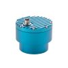
VEGA VEGAPULS C 23 Radar Water Level Sensor
Features
- Measuring range up to 30m with ≤ 2mm accuracy
- Low power consumption with flexible operating voltage from 8 to 30 VDC
- Integrated Bluetooth for configuration and SDI-12 output for data logger interface
- Free ground shipping
- Expedited repair and warranty service
- Lifetime technical support
- More
Overview
The VEGAPULS C 23 is the ideal radar sensor for non-contact level measurement with high accuracy requirements in all standard applications where a high degree of protection and particularly good signal focusing are required.
Diverse Environmental Applications
It is particularly suitable for level measurement in water treatment, in pumping stations and rain overflow basins, for flow measurement in narrow channels, for level monitoring in rivers and lakes and for many other environmental applications.
Measure Solids and Liquids
The sensor is suitable both for measuring liquids and for use on bulk solids silos or bulk solids containers. The device is designed for connection to data loggers with SDI-12 interface, making it particularly suitable for battery-powered applications requiring low power consumption as well as applications with one signal and supply cable for several sensors.
Select Options


In The News

Safeguarding Communities with Real-Time Flood Monitoring in the City of Hazelwood
The City of Hazelwood is a suburb in St. Louis County, Missouri, home to around 25,500 people. Recently, the community has suffered increased flash flooding following severe storms, prompting the need for the installation of a flood monitoring system. In 2022, a NexSens X2 data logger was installed to monitor water level and rainfall in real-time, with the aim of reducing the loss of life and property as a result of extreme weather events. [caption id="attachment_39411" align="alignnone" width="940"] The latest flood event at Coldwater Creek, where the water level rose by 14 feet, exceeding the height of the X2 by three feet. The sensor can be seen behind the wall that usually contains the Creek.
Read More
Monitoring Mariculture in the Gulf of Alaska
The mariculture industry in the Gulf of Alaska has been steadily growing in recent years, guided by ongoing research to help refine farm location and cultivation practices. A subset of aquaculture, mariculture focuses on rearing organisms in the open ocean. In Alaska, finfish farming is illegal, so most farms cultivate kelp, oysters, or a combination of the two. These small, locally operated farms started popping up in the Gulf of Alaska in the early 1990s, when shellfish farming first became legal. Kelp farming did not begin to catch on in the state until 2016. Many of the coastal areas that have grown interested in mariculture are historically commercial fishing communities.
Read More
Supplying Seattle’s Drinking Water: Using Data Buoys to Monitor the Cedar River Municipal Watershed
Providing clean, safe, and reliable drinking water for the 1.6 million people in the greater Seattle area is a top priority for Seattle Public Utilities (SPU). With limited water supplies, SPU dedicates considerable resources to maintain its watersheds and mountain reservoirs. About 70 percent of Seattle Water comes from the Cedar River Municipal Watershed , and the other 30 percent comes from the South Fork Tolt River Watershed . [caption id="attachment_39574" align="alignnone" width="940"] Data buoy in Chester Morse Lake . (Credit: Kevin Johnson / Seattle Public Utilities) [/caption] Jamie Thompson, a fisheries biologist at SPU, monitors aquatic ecosystems centered on fish listed under the U.S. Endangered Species Act (ESA).
Read More