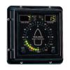
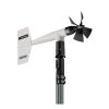
YOUNG Marine Wind Trackers
Features
- Wind speed is displayed in your choice of unitsKNOTS, MPH, KM/H, M/S
- Wind direction information is clearly displayed on a circular compass pattern of LEDs
- A variety of inputs and outputs including 4-20 mA, Serial NMEA & Voltage are standard
- Free ground shipping
- Expedited repair and warranty service
- Lifetime technical support
- More
Overview
The RM YOUNG 06206 Marine Wind Tracker offers special features for shipboard use. Wind speed is displayed in the user's choice of units: KNOTS, MPH, KM/H, M/S. Maximum wind speed is saved on the display until reset by the operator. 4-20 mA inputs, Serial NMEA, and Voltage outputs are standard on the Marine Wind Tracker. Alarms for both wind speed and wind direction are included.
Design
Wind direction information is clearly displayed on a circular pattern of LEDs. Bold front panel graphics give a quick indication of wind angle relative to vessel heading. Brightness control allows adjustment for best viewing in any light. Luminous front panel markings allow viewing even in a darkened pilothouse.
The Marine Wind Tracker is very compact. The face size is 144mm x 144mm to fit standard DIN panel configurations. Depth is 36mm for easy mounting on vertical bulkheads or wall surfaces. 12-30 VDC input power enables the Wind Tracker to be powered by the ship's batteries. A universal mounting bracket and AC wall adapter are also included. The Model 06260 Protective enclosure offers extra protection for wet or dusty locations.
In The News
UNC's industry-standard water quality profiling platforms get upgrade
The University of North Carolina Institute Of Marine Sciences has a history with profiling platforms. UNC engineers and scientists have been building the research floaters for 10 years in a lab run by in Rick Luettich, director of the institute. UNC scientists and engineers developed their own autonomous vertical profilers to take water quality readings throughout the water column. They have three profilers placed in the New and Neuse rivers. The profilers are designed to drop a payload of sensors to an allotted depth at set time intervals. Instruments attached take readings continuously on the way down and up. Data collected by the profilers has been used to study water related issues such as infectious disease and sediment suspension.
Read MoreUSGS weather station network monitors Arctic Alaska's climate
When the U.S. Geological Survey began building their climate and permafrost monitoring network in Arctic Alaska in 1998, there wasn't much precedent for how to build the infrastructure for the instruments in the region's unforgiving environment. That meant the scientists had to learn the particulars on the fly. For example: On the great expanse of flat, barren tundra, a weather station sticks out like a sore thumb to a curious grizzly bear. "The initial stations were pretty fragile," said Frank Urban, a geologist with the USGS Geosciences and Environmental Change Science Center. "So the bear and those stations--the bear won every single time without any problem.
Read MoreSave our Bogs! Culture, Conservation and Climate Action in Ireland’s Peatlands
Characterized by long-term accumulation under waterlogged conditions, peatlands exist on every continent and account for 3-4% of the global land surface . Small but mighty, these often overlooked wetland environments are estimated to hold as much as one-third of the world's organic carbon in their soil—twice the amount found in the entirety of the Earth's forest biomass. While healthy peatlands can trap and store carbon, regulate water, and provide important habitats for rare species, human alteration has disturbed peatland carbon and nitrogen cycles on a global scale. Approximately 12% of the world’s peatlands have been drained and degraded through conversion for agriculture, forestry, infrastructure development, and other uses.
Read More


