
YOUNG ResponseONE Weather Transmitter
Features
- Measures ultrasonic wind speed and direction, atmospheric pressure, humidity and temperature
- Serial output formats include SDI-12, NMEA, and ASCII text
- Wiring connections are made in a convenient weather-proof junction box
- Free ground shipping
- Expedited repair and warranty service
- Lifetime technical support
- More
Overview
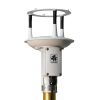
The YOUNG Model 92000 ResponseONE Weather Transmitter measures four key meteorological variables with one compact instrument. It is ideal for many weather monitoring applications requiring accurate and reliable measurements. Ultrasonic wind speed and direction, atmospheric pressure, humidity and temperature sensors are carefully integrated into an enclosure optimized for durability, airflow and mitigation of solar radiation effects. Terminals are provided for connection of an optional tipping bucket rain gauge (sold separately).
Calibrated and Tested
Each sensor is fully wind tunnel tested and calibrated to provide accurate wind measurement over a wide operating range. Standard serial output formats include SDI-12, NMEA, and ASCII text. Output may be continuous or polled to conserve power. Standard RS-232 or RS-485 serial formats enable direct integration with YOUNG displays, marine NMEA systems, data loggers or other compatible serial devices. The sensor mounts on a standard 1-inch IPS pipe. A mounting orientation ring is included that engages with the base of the sensor to retain orientation when the sensor is removed for maintenance. Terminations are made in a junction box at the base of the sensor by small clamp-style connectors (no special connectors are required). The YOUNG Model 92500 ResponseONE Weather Transmitter includes an internal compass to provide orientation for wind direction, making it ideal for mobile or portable applications.
Variables
- Ultrasonic wind speed and direction
- Atmospheric pressure
- Humidity
- Temperature
Wind Speed:
Range: 0–70 m/s (156mph)
Resolution: 0.01 m/s
Accuracy:
±2% or 0.3 m/s (0–30m/s)
±3% (30 – 70 m/s)
Wind Direction:
Azimuth Range: 0-360 degrees
Resolution: 0.1 degree
Accuracy: ±2 degrees
Temperature:
Range: -40 to +60°C
Resolution: 0.1°C
Accuracy: ±0.5°C
Relative Humidity:
Range: 0–100%
Resolution: 1%
Accuracy: ±2%
Atmospheric Pressure:
Range: 500–1100 hPa
Resolution: 0.1 hPa
Accuracy: ±0.5 hPa
Electronic Compass (Model 92500):
Range: 0–360 degrees
Resolution: 0.1 degree
Accuracy: ±2.0 degrees
Serial Output (selectable):
Interface: RS-232, RS-485/422, SDI-12
Formats: NMEA, SDI-12, ASCII (polled or continuous)
Baud Rates: 1200, 4800, 9600, 19200 and 38400
Power
Voltage: 10–30 VDC
Current: 7 mA @ 12 VDC typical, 80 mA max
General
Protection Class: IP65
EMC Compliance: FCC Class A digital device, IEC Standard 61326-1
Dimensions: 30 cm high x 13.5 cm wide
Weight: 0.7 kg (1.5lb)
Shipping Weight: 1.6 kg (3.5lb)
Operating Temperature: -40 to +60°C
Removable Bird Spikes: Included
Select Options


In The News

Three Decades of Research at Acton Lake
A multi-disciplinary team at Miami University, Ohio, has been studying the environmental change at Acton Lake for over three decades. Using three different NexSens buoys over this time, the team has an incredible archive of data that is helping build a picture of Acton’s past, present, and future. Until recently, a NexSens CB-50 buoy was used alongside other environmental monitoring at Acton Lake. In May 2025, the Miami team deployed a new XB-200 buoy , future-proofing their ongoing monitoring using real-time buoy systems. Acton Lake, a small hypereutrophic reservoir in southwest Ohio, covers 2.4km² and has a maximum depth of about 8m. The dam was built in 1956, and the lake has a large agricultural watershed.
Read More
Source Water Monitoring in Albany, New York: Tracing Water Quality throughout Tributaries
Thousands of US cities pull their drinking water from natural source waters like reservoirs, rivers, and streams, making overall watershed health a key consideration for water providers. In Albany, New York, the Albany Department of Water and Water Supply delivers drinking water to over 100,000 residents as well as monitors and manages the larger drinking water supply watershed. Hannah Doherty, Environmental Specialist at the Albany Department of Water and Water Supply , spends her days working with a small team to monitor the drinking supply and the connected water bodies. Doherty explains, “We’re the first to encounter the water that ends up being the drinking water.
Read More
Wildfire Prevention in the Sierra Nevada Region with the Yuba Watershed Institute
Though recent wildfires have sparked new conversations about wildfire management and response, groups like the Yuba Watershed Institute have been monitoring the forests and water resources of the Sierra Nevada region for decades, managing approximately 5,000 acres of land with the Bureau of Land Management (BLM) and about 7,000 acres in private land partnerships. The goal of the Institute is to work with local communities and land agencies to improve watershed and forestry management through informed practices and public outreach. The goals of the Yuba Watershed Institute are three-fold: Improve the ability of fire suppression agencies like the California Department of Forestry and Fire Protection ( CAL FIRE ) and the US Forest Service.
Read More