
HOBOnet Wireless Water Level Sensor Interface
Features
- 900 MHz wireless mesh self-healing technology
- 450 to 600 meter (1,500 to 2,000 feet) wireless range and up to five hops
- Up to 50 wireless sensors or 336 data channels per HOBO RX station
- Free ground shipping
- Expedited repair and warranty service
- Lifetime technical support
- More
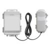
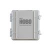
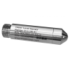
The HOBOnet water level sensor interface features a pre-configured, easily deployed wireless sensor that communicates accurate, reliable water level data directly to a HOBO RX3000 or HOBO MicroRX station, the core component of the HOBOnet remote monitoring system.
HOBOnet is a cost-effective, scalable, user-friendly wireless sensor network that lets you streamline data retrieval by effortlessly monitoring multiple wells with a single cellular device. Data is accessed from anywhere, at any time, through the customizable dashboard in HOBOlink, Onset's innovative cloud software platform – eliminating the need for frequent site visits that are both time-consuming and costly. HOBOlink also sends automatic, real-time text/email notifications to alert you of any sensor or system alarms, providing the insights you need to make informed decisions, react quickly to stay ahead of issues, and ensure compliance.
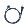
A complete system requires at least one HOBOnet Water Level Sensor, a direct read cable, and a HOBO RX3000 Remote Monitoring Station and HOBOnet Wireless Manager (or a HOBO MicroRX Station with an integrated HOBOnet Wireless Manager). HOBOnet Wireless Repeaters can be added to extend the range.
Select Options


In The News

Data-Driven Advocacy on the Lower Deschutes River
Like many freshwater environments, the Deschutes River in Oregon is under pressure from development, pollution, and climate change. Many rivers, streams and lakes in the Deschutes Basin do not meet Oregon water quality standards –where state water quality monitoring assesses levels of bacteria, pH, dissolved oxygen, temperature, and fine sediment. Hannah Camel is the Water Quality Coordinator for the Deschutes River Alliance (DRA), a non-profit organization that focuses on the health of the lower 100 miles of the Deschutes River–the area most affected by human intervention. As a data-driven organization, the DRA has benefited from the installation of two NexSens X2 data loggers.
Read More
Expanding the Port Everglades: Real-Time Monitoring of Water Quality Conditions from Planned Dredging Operation
The Port Everglades in Broward County, Florida, serves large trade vessels and cruiseliners and incoming and outgoing recreational boaters. However, as cargo ships become larger, the port must expand. A dredging project led by the US Army Corps of Engineers will substantially deepen and widen the port's navigation channel to accommodate larger Panamax cargo ships and modern cruise liners. As a result of this project, a large amount of sediment will be displaced into the water column. This suspended sediment may settle outside of the project area, burying benthic organisms like corals, and possibly carrying harmful particulates to other regions. [caption id="attachment_39497" align="aligncenter" width="2560"] A CB-950 and CB-25 deployed on site at Port Everglades.
Read More
It’s Time to React to Water Quality: Proteus Multiparameter Probe aboard NexSens Buoy
Water quality monitoring is essential for safeguarding public health, protecting ecosystems, and ensuring the sustainability of water resources. Contaminants such as industrial pollutants, agricultural runoff, and sewage discharge can severely impact aquatic life and pose serious risks to human health if left unchecked. Traditionally, water quality monitoring has been a slow and labor-intensive process, requiring samples to be collected, transported to a lab, and analyzed—a process that can take days. However, with the advancement of real-time sensor technology, environmental agencies, researchers, and industries can now monitor water quality instantly.
Read More