
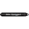
Solinst LevelSender 5 Cellular Telemetry System
The Solinst LevelSender 5 is a simple, low-cost system designed to wirelessly send data from Solinst dataloggers in the field, via cellular communication, to multiple emails and an SMS recipient.
Features
- Sized to fit inside a standard 2" well casing
- Remote data sent via email or SMS messaging
- Use database to import to a website or list
- Free ground shipping
- Expedited repair and warranty service
- Lifetime technical support
- More
Overview
The Solinst Level Sender 5 receives data on any chosen smart device. Solinst provides the option of a pre-programmed LevelSender with a 4G SIM APN setup. The Solinst SIM card scans multiple networks and connects to the strongest signal. Low-cost, data-only plans are billed directly through Solinst for convenience and can be purchased here https://solinstcloud.com/login/register.php
*Verizon SIM cards are not compatible
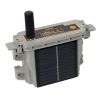
Compact Remote Stations
Can be discreetly installed inside a 2" diameter monitoring well or other housing. Each LevelSender 5 device has a single port to connect one datalogger. An optional splitter provides connections for two dataloggers, allowing the installation of a Levelogger and Barologger in the same well. Along with water level, temperature, conductivity, barometric, or rainfall data, battery level, and status updates from the remote LevelSender 5 are received with each data report.
Solinst Cloud
LevelSender telemetry system users can opt-in to the Solinst Cloud web-based data-management tool that enables the configuration and management of remote devices. Quickly view and assess remote projects, set alarms, download reports, and more using the online dashboard. Data plans start at no cost, with the option for expanding to low-cost plans for managing a larger network of Leveloggers.
LevelSender telemetry devices work with the LevelSender 5 using the following loggers:
- Solinst Levelogger 5 Series
- LevelVent 5
- Levelogger Edge Series
- LevelVent loggers
- Modem: 4G LTE UE Category M1/NB1 device (850/900/1800/1900 MHz)
- SIM Card: Standard SIM (15mm x 25mm); option of Solinst SIM or through service provider of client’s choice
- Communication: Email or SMS data transfer, Dynamic IP
- Antenna: SMA Male Monopole 2dBi
- Data File Type: text, .xle, .sqlite
- Sampling Interval: 1 minute - 99 hours
- Reporting Interval: 5 minutes - 99 hours
- Schedule Programming: Directly via USB-C connection on the LevelSender or remotely via LevelSender Software (email)
- Power Supply: 3 x AA 1.5V replaceable lithium batteries
- Battery Life Example: Hourly sampling and daily reporting: 4 years with 1 datalogger, 3.3 years with 2 dataloggers
- Operating Temperature: -20ºC to 60ºC
- IP Rating: IP67
- Materials: Black Delrin, 316 stainless steel
- Size: 2.5" x 9.375" (with antenna folded down)
- Weight: 16.9 oz. (478 grams)
- Compatible Dataloggers: Levelogger 5 Series dataloggers, LevelVent 5, AquaVent 5, as well as previous versions of the LevelVent and AquaVent, and Levelogger Edge Series dataloggers
- Number of Connected Leveloggers: 1, or 2 using a splitter
- Barometric Compensation: Internal barometer for automatic barometric compensation of water level data if a Barologger is not being used (not required for vented loggers)
- Internal Barometer Range: 30 kPa - 120 kPa
- Internal Barometer Accuracy: ±0.2 kPa (20 cm)
- (1) LevelSender
- (1) 2" Well Cap
- (1) Hanger Bracket
- (1) Set of Batteries
- (1) Antenna
Select Options


In The News

Data-Driven Advocacy on the Lower Deschutes River
Like many freshwater environments, the Deschutes River in Oregon is under pressure from development, pollution, and climate change. Many rivers, streams and lakes in the Deschutes Basin do not meet Oregon water quality standards –where state water quality monitoring assesses levels of bacteria, pH, dissolved oxygen, temperature, and fine sediment. Hannah Camel is the Water Quality Coordinator for the Deschutes River Alliance (DRA), a non-profit organization that focuses on the health of the lower 100 miles of the Deschutes River–the area most affected by human intervention. As a data-driven organization, the DRA has benefited from the installation of two NexSens X2 data loggers.
Read More
Expanding the Port Everglades: Real-Time Monitoring of Water Quality Conditions from Planned Dredging Operation
The Port Everglades in Broward County, Florida, serves large trade vessels and cruiseliners and incoming and outgoing recreational boaters. However, as cargo ships become larger, the port must expand. A dredging project led by the US Army Corps of Engineers will substantially deepen and widen the port's navigation channel to accommodate larger Panamax cargo ships and modern cruise liners. As a result of this project, a large amount of sediment will be displaced into the water column. This suspended sediment may settle outside of the project area, burying benthic organisms like corals, and possibly carrying harmful particulates to other regions. [caption id="attachment_39497" align="aligncenter" width="2560"] A CB-950 and CB-25 deployed on site at Port Everglades.
Read More
It’s Time to React to Water Quality: Proteus Multiparameter Probe aboard NexSens Buoy
Water quality monitoring is essential for safeguarding public health, protecting ecosystems, and ensuring the sustainability of water resources. Contaminants such as industrial pollutants, agricultural runoff, and sewage discharge can severely impact aquatic life and pose serious risks to human health if left unchecked. Traditionally, water quality monitoring has been a slow and labor-intensive process, requiring samples to be collected, transported to a lab, and analyzed—a process that can take days. However, with the advancement of real-time sensor technology, environmental agencies, researchers, and industries can now monitor water quality instantly.
Read More